


Getting Around Kuala Lumpur Without a Car | MRT, LRT, Grab & the Walking Reality


You Really Don't Need a Car in Kuala Lumpur
We spent two full weeks in Kuala Lumpur without a car and never once felt that renting one would have made life easier. In fact, because we were staying in Bukit Bintang, one of the most central parts of the city, having a car would probably have been more of a headache than a convenience.
KL is one of those cities where “you don't need a car” and “you can walk everywhere” are two completely different statements.
Traffic at peak times can be intense, and parking is not always straightforward. Cars and motorbikes seem to squeeze into every available space — sometimes whether they should be there or not.
Thankfully, getting around Kuala Lumpur without your own vehicle is surprisingly easy. Public transport is inexpensive and fairly straightforward once you understand the network, while Grab is useful for places the rail system doesn't quite reach., while Grab is useful for places the rail network doesn't quite reach. But Grab isn't necessarily faster: when Kuala Lumpur traffic stops, everyone stops.
Walking is where things become more complicated.
Some neighbourhoods are perfectly enjoyable to explore on foot. Bukit Bintang was easy, and walking towards Petaling Street was pleasant enough. But a route that looks simple on a map can turn into something very different on the ground.
Then there is the heat and humidity, sudden disappearing pavements and the fact that a red traffic light does not always mean every motorbike is going to stop.
That is the reality of getting around Kuala Lumpur: individual neighbourhoods can be very walkable, but the city as a whole is not always pedestrian-friendly. Distances that look short on Google Maps can be surprisingly awkward once you are actually standing on the street.
In this guide, I'll explain what genuinely worked for us during two weeks in Kuala Lumpur — when we used the MRT and LRT, when Grab made more sense, when walking was enjoyable and when it really wasn't — so you can explore the city without needing to rent a car.
Still deciding whether Kuala Lumpur deserves a place on your Malaysia or Southeast Asia itinerary? Before diving into the practicalities of getting around, read our Is Kuala Lumpur Worth Visiting? A Slow Travel Guide to Culture, Food, Nature & City Life for an honest look at what it’s actually like to spend time in Malaysia’s capital — beyond the Petronas Towers and the usual tourist highlights.
Can You Get Around Kuala Lumpur Without a Car?

Yes. Very easily, in fact.
You don’t replace a car with one transport method, you replace it with a combination of:
MRT/LRT + Monorail + walking + Grab.
That combination is what makes KL easy.
Transport | Best for | Our verdict |
MRT/LRT | Longer journeys across KL | Excellent |
Monorail | Central KL/Bukit Bintang | Useful |
Grab | Last-mile, awkward routes, tourist attractions | Extremely useful |
Walking | Exploring individual neighbourhoods | Good in the right places |
Bus | Certain routes / when convenient | Useful but not our first choice |
Rental car | To drive away from KL | Useful if your destination has no public transport or Grab available |
Why Kuala Lumpur Looks Easier on a Map Than It Feels on the Ground
Kuala Lumpur can be surprisingly deceptive when you look at it on a map. Attractions often appear close together, train stations seem conveniently placed, and a 15-minute walk does not sound like much. On the ground, though, getting from A to B can feel very different.
One of the biggest reasons is that Kuala Lumpur was not designed as a particularly pedestrian-friendly city. Major roads, flyovers, multi-lane junctions, construction sites and large developments regularly interrupt what looks like a simple walking route. A destination may only be a few hundred metres away in a straight line, but reaching it can involve finding a pedestrian crossing, using an overhead bridge, walking around an entire block or entering a shopping centre simply to get through to the other side.

We noticed this repeatedly during our two weeks in Kuala Lumpur.
Sometimes we could actually see where we wanted to go, yet there was no obvious or direct way to reach it on foot. Pavements can suddenly disappear, crossings are not always where you expect them to be, and Google Maps occasionally suggests routes that make perfect sense digitally but feel awkward once you are standing beside six lanes of traffic wondering where pedestrians are supposed to go.
A 15- or 20-minute walk in Kuala Lumpur is very different from the same walk somewhere cooler. High temperatures, humidity and intense sun can make relatively short distances tiring, particularly in the middle of the day. Add a backpack, camera equipment or sudden tropical rain and you may quickly decide that taking the MRT or calling a Grab is worth it, even for a distance you would normally walk.
This is particularly noticeable around areas such as Bukit Bintang and KLCC. On a map, many of the major attractions appear to sit almost beside one another. And in some cases they do. But roads, shopping complexes and large buildings can turn those short distances into surprisingly indirect routes.
The good news is that Kuala Lumpur has adapted to this in places.
Covered walkways, pedestrian bridges and shopping malls often become part of the walking network itself. The covered KLCC–Bukit Bintang pedestrian walkway, for example, makes travelling between two of the city's busiest areas considerably easier and protects you from both the heat and rain.
Once we understood how Kuala Lumpur worked, getting around became much easier. We stopped looking only at distance and started thinking about how that distance would actually be covered.

Heat, Humidity, Disappearing Pavements, Crossings and Motorbikes
This is where walking in Kuala Lumpur can become almost comical.
Imagine Google Maps tells you your destination is only 1.2 kilometres away. Easy. You start walking. For the first 500 metres, everything is fine. There is a pavement, you are heading in the right direction, and your destination is getting closer.
Then the pavement simply ends.
Not narrows. Not becomes slightly inconvenient.
It ends.
Suddenly you are standing beside what is effectively a four-lane highway with no safe pedestrian route ahead.
So you turn around.
You walk the same 500 metres back, meaning you have now walked a kilometre and are almost exactly where you started. Then you open Google Maps again and try to work out another way around. At this point, you may be reading this and thinking: surely it cannot be that difficult to walk from A to B.
Trust me. Sometimes it really is.
You find another route, only to realise that the road you need to cross has no pedestrian crossing nearby. The nearest footbridge might be another kilometre away, which means walking in the opposite direction before crossing and then doubling back again on the other side.
Meanwhile, it is 32°C, the humidity is high, there is little or no shade, and you are walking beside constant traffic.
That original 1.2-kilometre walk can suddenly become two or three kilometres — sometimes more.
And this is why walking distances in Kuala Lumpur are deceptive.
It is not necessarily the distance itself that is the problem. It is the lack of continuous pedestrian infrastructure.
Pavements can disappear. Roads can be surprisingly difficult to cross. Flyovers and multi-lane junctions can block what looks like an obvious route. Construction can force detours. And sometimes the only sensible option is to walk backwards before you can move forwards.
Motorbikes add another layer.
They are everywhere in Kuala Lumpur, and while most of the time they are simply part of the background traffic, as a pedestrian you need to remain aware of them around junctions, entrances, side roads and occasionally pedestrian areas. Traffic can come from directions you are not expecting, especially when you are concentrating on trying to work out where the pavement has gone.
Then add the tropical climate.
Walking one kilometre in Kuala Lumpur is not the same as walking one kilometre in a cool European city. With strong sun, high humidity and very little shade along some roads, even short detours can become exhausting.
This was one of the biggest adjustments we had to make.
We stopped asking, “How far away is it?”
Instead, we started asking, “Can we actually walk there?”
Those are two very different questions in Kuala Lumpur.

MRT, LRT & Monorail — What Visitors Need to Know
At first glance, Kuala Lumpur's rail system can look more complicated than it actually is. There are MRT lines, LRT lines, a Monorail, KTM trains and airport rail services, all appearing together on the same transit map.
In reality, as a visitor, you don't need to understand the technical differences between all of them. What matters is knowing that they are different parts of the same wider public transport network, and you will often use more than one during your stay.
MRT: the one we found most useful
The MRT is Kuala Lumpur's newer mass transit system, with two lines currently operating: the Kajang Line and Putrajaya Line. Both travel through central Kuala Lumpur before extending far into the wider Klang Valley.
For visitors, the Kajang Line is particularly useful because it serves places such as Muzium Negara/KL Sentral, Pasar Seni, Merdeka, Bukit Bintang and TRX.
The Putrajaya Line also passes through the city centre, including Titiwangsa, Ampang Park, Persiaran KLCC, Conlay and TRX, before continuing south towards Putrajaya.
The MRT was probably the easiest part of Kuala Lumpur's rail network for us to get our heads around. Stations are modern, signage is generally clear, and once you know the station closest to where you are going, the journey itself is usually straightforward.
And considering what we have just said about walking in Kuala Lumpur, being able to travel several kilometres across the city underground or above the traffic can feel like a blessing.
LRT: older, but incredibly useful
Kuala Lumpur also has three main LRT services: the Kelana Jaya, Ampang and Sri Petaling lines.
You do not need to memorise those either.
The important thing to know is that the LRT fills in many of the gaps between the MRT routes and connects a huge number of neighbourhoods, transport hubs and central areas. Depending on where you stay, you may actually use the LRT more frequently than the MRT.
This is where looking at Kuala Lumpur's network as one integrated system becomes much more useful than thinking about MRT and LRT separately.
If your route planner tells you to take the MRT for three stops, change to the LRT and continue for another four, there is nothing unusual about that. It is simply how the network fits together.
And then there's the Monorail
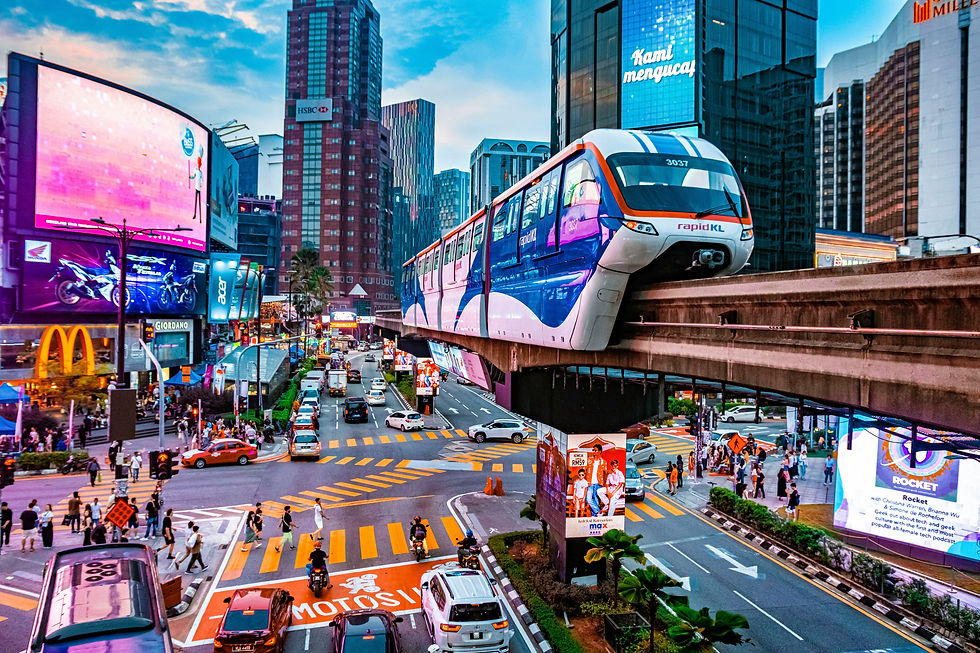
The KL Monorail is much smaller and easier to understand.
It runs through a relatively short section of central Kuala Lumpur and is particularly useful around Bukit Bintang and several surrounding neighbourhoods before connecting towards KL Sentral.
If you stay around Bukit Bintang, as we did, you are likely to notice it immediately — the trains run above the streets through some of the busiest parts of the city.
The Monorail is not something you need to plan an entire trip around, but for certain short journeys through central KL it can be extremely convenient.
Changing lines is normal
One thing that may reassure you before arriving is that changing between different rail systems is completely normal in Kuala Lumpur.
A journey may involve an MRT followed by an LRT, or a Monorail followed by another train.
Some interchanges are very straightforward. Others involve a little more walking than you might expect, and stations that function as connections are not always literally on top of one another.
Don't assume KL Sentral is where every journey begins
KL Sentral is Kuala Lumpur's main transport hub, but you do not need to travel through it every time you change trains. There are plenty of useful interchanges elsewhere in the city. TRX, for example, connects the Kajang and Putrajaya MRT lines, while other stations link MRT, LRT, Monorail and KTM services.
In practice, KL Sentral is important — just not the centre of every journey.
The network makes much more sense once you start using it
You don't need to learn the entire network. You really only need to know where you are, where you want to go and which station is closest to each.

How to Pay for Public Transport in Kuala Lumpur
Paying for public transport in Kuala Lumpur is fairly straightforward, but the method depends on what you’re using.
For the MRT, LRT and Monorail, you can buy a single-journey token at the station or use a Touch ’n Go card, Malaysia’s rechargeable transport card. Single-journey tokens are bought for a specific destination from the ticket machines at MRT, LRT and Monorail stations, so they are perfectly adequate if you are only making occasional journeys. If you’re staying in KL for more than a few days and using public transport regularly, a Touch ’n Go card is the more convenient option because you simply tap in and out.
For KTM Komuter trains, including the route to Batu Caves, tickets can be bought at stations or through KTMB’s official booking channels. KTM also accepts several cashless payment methods, including bank cards and Touch ’n Go.
What About Buses?
For regular Rapid KL buses, Touch ’n Go is the simplest option. These services are cashless, and direct tap-in/tap-out with ordinary debit or credit cards is not yet available across the regular Rapid KL bus network.
Touch ’n Go Card
The Touch ’n Go card is Malaysia’s rechargeable contactless payment card. You can use it for public transport, toll roads, parking and some other cashless payments. For travellers, its biggest advantage is convenience: instead of buying a ticket or token for every journey, you simply tap in and out.
We actually didn’t use one while we were in Kuala Lumpur. At the time, we hadn’t realised how useful they could be, so we simply bought our train tickets with cash.
We eventually got one later in Penang when we rented a car, because we needed it for toll payments when crossing between Penang Island and the mainland. So, once we had a car, it became much more useful.
For us, buying one specifically for Kuala Lumpur wouldn't have been essential. We weren't using public transport constantly, so paying for individual journeys worked perfectly well.

Where Can You Buy a Touch ’n Go Card?
You can normally find Touch ’n Go cards through authorised retailers and official sales channels. Availability can vary, so I wouldn’t rely on one particular convenience store having them in stock.
Common places to check include:
selected convenience stores, petrol stations and other authorised merchants
selected public transport stations and customer-service counters
the official Touch ’n Go online shop
the Touch ’n Go eWallet app for the enhanced NFC card
The newer enhanced Touch ’n Go card can be linked to the Touch ’n Go eWallet and reloaded using NFC from a compatible phone, which is useful if you are staying in Malaysia for longer.
For a short visit, however, I wouldn’t say you need one. If you are only using the MRT or LRT occasionally, buying individual journeys is perfectly manageable. If you are staying longer, using public transport frequently or renting a car and driving on toll roads, the card becomes much more worthwhile.
How to Reload a touch ’n Go Card
Touch ’n Go cards can be reloaded at Rapid KL customer-service counters and various authorised reload locations. If you have the enhanced NFC card and a compatible phone, you can also reload it directly through the Touch ’n Go eWallet app.

Is Kuala Lumpur Public Transport Easy to Use?
Eventually, yes.
But I wouldn't say Kuala Lumpur's public transport system was immediately easy to understand.
Once we knew which station we needed, which line we were taking and where we had to change, the trains themselves were generally straightforward. Stations are well maintained, the rail network covers a large part of the city, and after a few journeys we became much more confident using it.
Learning how the system fitted together was the difficult part.
During our first few days, we relied heavily on local people and ticket-office staff to work out how to get from A to B.
Google Maps usually gave us a reasonable starting point, but it wasn't always clear when a journey involved several systems or an interchange. A simple-looking change could involve walking through long station corridors or even continuing from a nearby station with a different name. The first few times this happened, we genuinely wondered whether we were going the right way.
We also found the official public transport websites surprisingly difficult to navigate. There were occasions when we found what appeared to be a ticket-purchase section but couldn't actually complete the purchase, or couldn't find a clear answer to what should have been a simple journey question.
So particularly at the beginning, asking someone was often the quickest solution. Ticket-office staff and local passengers helped us many times, although language differences occasionally made things a little harder.
One KL-specific quirk worth knowing is that connected stations can sometimes have different names. Muzium Negara, for example, is the MRT station serving the KL Sentral area.
I think there is a real difference between saying “the system is easy to use” and saying “the system is easy to learn.”
For us, learning it took a little time. Using it, once we understood how the pieces fitted together, was much easier.
And if we were still unsure?
We asked someone.
That was often far more useful than staring at our phones for another ten minutes.

Grab in Kuala Lumpur
Grab became one of the most useful ways for us to get around Kuala Lumpur.
The rail network covers a lot of the city, but there are still places that are awkward to reach without a car, particularly once you move beyond the central MRT and LRT corridors. Places such as Kanching Rainforest Waterfall, some trailheads and greener areas around the edge of the city can be much easier to reach by Grab than by combining trains, buses and a long final walk.
The only thing to bear in mind is the return journey. Getting a Grab to a more remote place can be easier than finding one to bring you back into KL, so it is worth checking availability before relying on it completely.
And then there is the weather.
A beautiful sunny morning in Kuala Lumpur can turn remarkably quickly into one of those spectacular tropical downpours where the sky seems to empty itself all at once.
At that point, there is very little glory in trying to save a few ringgit by figuring out which bus will eventually deposit you somewhere vaguely near your apartment.
You order a Grab.
One of the biggest advantages is simply that the car comes to you. You enter your pickup point and destination in the app, see the fare before confirming, and your driver collects you from the selected location and drops you at the other end.
In a city where the final 700 metres can occasionally involve a missing pavement, six lanes of traffic and questionable life choices, that convenience is worth quite a lot.
We generally used public transport when there was an easy rail connection and Grab when the journey started becoming unnecessarily complicated.
That does not mean Grab is always quicker.
During rush hour, Kuala Lumpur traffic can be extraordinary. A journey that takes ten or fifteen minutes at a quieter time can take considerably longer during peak traffic, so check the journey estimate in the app before booking rather than assuming a car will automatically be faster.
Sometimes the MRT wins very easily.
Grab vs Train: Which Should You Use?
Situation | Usually makes more sense |
Long journey with convenient stations at both ends | MRT/LRT |
Destination far from rail | Grab |
Heavy rain | Grab |
Peak-hour journey along a rail corridor | MRT/LRT |
Travelling with luggage | Grab |
Several people travelling together | Compare the Grab fare |
Short journey involving awkward walking | Grab |
The easiest way to get around Kuala Lumpur is to use rail and Grab together, choosing whichever makes the most sense for each journey.
How Much Does Grab Cost in Kuala Lumpur?
Grab was remarkably affordable during our time in Malaysia.
We sometimes paid the equivalent of around €2 or less for a short journey of roughly 15 minutes, although that should be treated as an example from our own travels rather than a fixed fare.
Prices change according to distance, estimated journey time and demand. Grab uses dynamic pricing, so fares can rise during rush hour, heavy rain and other periods when lots of people are requesting rides.
The price shown in the app before you book is therefore much more useful than trying to memorise a per-kilometre fare.
One Grab Quirk We Encountered
Grab uses its own mapping and pickup system, and occasionally the exact place we were standing simply didn't appear as a selectable location.
This happened to us several times in Malaysia.
The easiest solution was to look around for a nearby hotel, shop, restaurant or recognisable building that did appear in Grab and use that as the pickup point instead.
It can be slightly irritating when you're standing exactly where you want to be collected and the app insists that, cartographically speaking, you apparently don't exist.
But overall, Grab worked extremely well for us in Kuala Lumpur and across Malaysia, and we would absolutely use it again.
Getting around Kuala Lumpur's Main Sights Without a Car
Place | Simplest car-free option |
KLCC / Petronas Towers | LRT to KLCC |
Bukit Bintang | MRT or Monorail |
Chinatown / Central Market | MRT/LRT to Pasar Seni |
Batu Caves | KTM Komuter |
Thean Hou Temple | Rail + Grab, or Grab directly |
Perdana Botanical Gardens / Bird Park | Rail + walk/Grab depending on your starting point |
These are deliberately simplified recommendations. The exact station, interchange, exit and walking route can vary depending on where you are starting from; I cover those journey details in the Kuala Lumpur guide.
Getting From Kuala Lumpur Airport to the City
Kuala Lumpur International Airport is quite a long way from central Kuala Lumpur, so this is one journey worth thinking about before you land.
Your main options are the KLIA Ekspres, Grab, an airport bus or a pre-booked private transfer.
We didn't actually use public transport when we arrived. After a long-haul night flight, with four suitcases between us and me nursing a pounding migraine, we booked a driver and let someone else deal with it.
Sometimes convenience wins.
For most travellers, the best option depends on where you are staying, how much luggage you have and what time you arrive.
KLIA Ekspres
The KLIA Ekspres is the fastest public-transport option between the airport and central Kuala Lumpur.
It runs between KLIA Terminal 1, Terminal 2 and KL Sentral, taking around 28 minutes from Terminal 1 to KL Sentral. The standard adult single fare is currently RM55, with a return fare of RM100.
Services run regularly throughout the day, but if you arrive late, check the current timetable before relying on the final trains.
The important thing to remember is that the train only gets you as far as KL Sentral.
If you are staying in Bukit Bintang, KLCC or elsewhere in the city, you will still need an onward connection by MRT, LRT, Monorail or Grab.
That makes the Ekspres excellent if you are staying near KL Sentral or travelling light, but not automatically the easiest option for every arrival.
What About KLIA Transit?
KLIA Transit uses the same airport rail corridor but stops at intermediate stations including Putrajaya & Cyberjaya and Bandar Tasik Selatan before reaching KL Sentral.
If you are simply heading into central Kuala Lumpur, the non-stop KLIA Ekspres is usually the more obvious choice. KLIA Transit is more useful when one of its intermediate stops suits your destination better.
Grab
Grab is the simplest door-to-door option.
You enter your accommodation in the app, see the fare before confirming and travel directly there without having to change transport at KL Sentral.
For couples or groups, Grab can be surprisingly competitive once you compare the total cost.
Two KLIA Ekspres tickets cost RM110 before any discount, and you may still need to pay for onward transport from KL Sentral.
So if you are travelling with several suitcases, staying nowhere near KL Sentral or simply want the easiest arrival, check the Grab fare before automatically buying train tickets.
The downside is traffic.
During rush hour, the train can be far more predictable than travelling by road.
Grab - Download the App: https://www.grab.com/my/
Airport Bus
Airport coaches are the budget option.
Services such as SkyBus connect KLIA with KL Sentral. The journey takes longer than the train and is affected by traffic, but it can make sense if keeping costs down matters more than speed.
Which One Should You Choose?
For most visitors:
Your situation | Probably the easiest option |
Staying near KL Sentral | KLIA Ekspres |
Travelling solo with light luggage | KLIA Ekspres |
Couple or group | Compare Grab with train cost |
Several large suitcases | Grab or private transfer |
Staying in Bukit Bintang/KLCC | Compare Grab with train + onward connection |
Travelling during heavy rush-hour traffic | KLIA Ekspres |
Very tight budget | Airport bus |
Arriving exhausted after a long-haul flight | Whichever requires the least thinking |
That final category was us.
Four suitcases, very little sleep and a migraine were more than enough reason to pay someone to take us directly to the door.
There is no medal for making your arrival unnecessarily difficult.

Should You Rent a Car in Kuala Lumpur?
For most visitors, no.
If you are staying in Kuala Lumpur itself, renting a car is unlikely to make life easier. Between the MRT, LRT, Monorail, Grab and buses, there is very little reason to deal with city traffic, parking and navigating KL’s roads yourself.
A car starts to make more sense when Kuala Lumpur is your base rather than your entire trip — particularly if you want to explore rural Malaysia.
It may also be worth considering if you are reading this because you are thinking about living in Kuala Lumpur or moving to Malaysia. The transport needs of a resident or long-stay digital nomad can be very different from those of a visitor staying for a few days.
You Don’t Need a Car for Malaysia’s Main Travel Route
If you want to travel from Kuala Lumpur to places such as Melaka, Cameron Highlands, Ipoh, Pangkor Island, Langkawi or Penang, you can usually do so without renting a car.
Malaysia has good intercity bus and rail connections between the main destinations, with ferries covering islands such as Pangkor and Langkawi.
Useful booking sites:
Redbus - https://www.redbus.my
12goAsia - https://12go.tpo.mx/Xww8a539
KTMB — https://www.ktmb.com.my/
If your itinerary follows the more established route between major towns and islands, public transport is usually enough.
When Renting a Car Starts to Make Sense
A car becomes genuinely useful when you want to leave those established routes behind.
Waterfalls, hiking trails, wildlife areas, villages and smaller rural communities can be difficult or impossible to reach independently by public transport.
Distances can also be deceptive. Malaysia is mountainous in many areas, and rural roads can be narrow, winding or slower than the map suggests, so a journey that looks short in kilometres can still take quite a long time.
If your priority is rural Malaysia rather than the main city-to-city route, that is when renting a car starts to become worthwhile.
Beyond Kuala Lumpur
Kuala Lumpur is a fantastic city, but don’t let the fact that rural Malaysia can require a car stop you from exploring further.
The east coast and more rural parts of the country feel very different from the better-known west-coast route, with wildlife, hiking, waterfalls, local food and small kampongs that are still far removed from mass tourism. This is where having your own car becomes less about transport and more about freedom — the freedom to stop when you want, stay longer somewhere you love and build a route that is entirely your own.
For longer journeys between major destinations such as Ipoh, Penang or other Malaysian cities, however, public transport is usually straightforward. I would simply book ahead rather than turning up and hoping for availability.
If you're still deciding whether KL deserves a place on your Malaysia itinerary, read Is Kuala Lumpur Worth Visiting? A Slow Travel Guide to Culture, Food, Nature & City Life.
Want to see what Kuala Lumpur actually feels like? We spent two weeks exploring the city — from its chaotic streets and night markets to temples, green spaces and the futuristic skyline. You can watch our Kuala Lumpur travel film on YouTube and experience the city with us.
Frequently Asked Questions
What is the best app for getting around Kuala Lumpur?
Google Maps is useful for planning most journeys, but we found it wasn’t always clear around interchanges or walking connections. MyRapid PULSE can help with the Rapid KL network, while Grab is the easiest option for ride-hailing. We wouldn’t rely on any one app blindly, especially for walking routes.
Can I use my debit or credit card on Kuala Lumpur public transport?
It depends on the transport system. Some services, such as KLIA Ekspres, accept contactless bank cards directly, while Rapid KL rail and buses are more commonly used with Touch ’n Go or individual tickets. Check the payment method for the specific service before travelling.
Can two people use the same Touch ’n Go card?
No. Each passenger needs their own card when travelling on services that require tapping in and out, because the system needs to record each individual journey separately.
What time does public transport stop running in Kuala Lumpur?
There isn’t one universal closing time. Most urban rail services run until late evening, but the last train depends on the line, station and direction. If you’re travelling late, check the current timetable before setting out and use Grab as a backup.
Is Google Maps reliable for getting around Kuala Lumpur?
Mostly, but not perfectly. We used it often and it usually pointed us in the right direction, but some interchanges were unclear and walking routes could look far easier on screen than they were in reality.
Do I need a Touch ’n Go card in Kuala Lumpur?
Not necessarily. If you’re only making occasional MRT or LRT journeys, single-trip tickets are perfectly manageable. A Touch ’n Go card becomes more worthwhile if you’re using public transport frequently, taking buses or travelling around Malaysia for longer.
Pin this for later!


Comments